The chalk vein
The chalk vein
Gps Track
Gps Track
- Start: Railway station Pian di Macina, Pianoro
- Arrival: Railway station Pian di Macina, Pianoro
- Total Length: 32,5 km
- Difficulty by Cycle: Hard
- Climb up: 850 m
- Climb down: 850 m
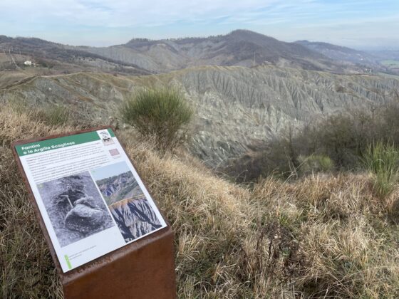
Leaving the railway station of Pian di Macina, that can be reached from Bologna with the bike + train service, start climbing along via di Campostrino until you climb over the hill and descend to Botteghino di Zocca. From here begins a nice uphill dirt track that, with some hard climbs, leads to the ruins of Casola Canina, which can be visited with the short detour indicated in the track where there are beautiful views of the Calanchi di Casola. Turning back, it is necessary to take a short stretch on a path (bike by hand) to rejoin the ridge road that, skirting the calanque formations, leads to the viewpoint of Gaibola. Here the road, now paved again, begins to descend.
After about 500 m, a fork on the right leads to a technically challenging downhill dirt section due to the presence of chalky outcrops on the path. Once past the first section (possibly by hand bike) the ground improves and then becomes paved and joins the road leading to the church of Pizzocalvo. Taking advantage of a few stretches of bicycle path, you arrive at Pulce, where a dirt road begins that leads to via Croara, near the church of Santa Cecilia, part of the UNESCO property “Messengers of a Culture of Peace.”
You take a left starting to climb but immediately turn right along Via Madonna dei Boschi, a nice paved road that crosses an area of the Parco dei Gessi rich in interesting places such as the ancient “wire” gypsum quarry, the formation known as “buca delle Candele,” the ancient Roman quarry known as “la Palestrina,” the Spipola cave and other places well indicated by the park’s information panels.
After the park’s large rest area, the road begins to climb with a few steep climbs until it reaches the Montecalvo church, an excellent place for a break and a water refill at the fountain. One more effort and you reach the scenic summit of Montecalvo, where the symbolic altar dedicated to Mater Pacis was laid in 2020.
From here you begin to descend along a path that is very steep and rocky in the initial section, possibly to be done by hand bike (about 400 mt. – it is advisable to keep left at the point where it branches into two parallel sections). The trail gradually becomes more rideable until it connects to the initial Campostrino road and from there quickly to the Pian di Macina station.