Discovering Ozzano's hills
Discovering Ozzano's hills
Gps Track
Gps Track
- Start: Ozzano dell’Emilia
- Arrival: Ozzano dell’Emilia
- Total Length: 45,1 km
- Cycle type: Mountain bike
- Difficulty by Cycle: Hard
- Climb up: 1000 m
- Climb down: 1000 m
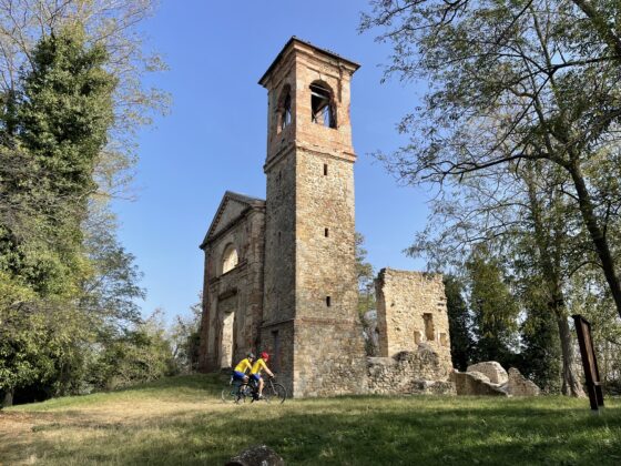
Leaving Ozzano we begin to climb on minor roads until we reach Via del Pilastrino, a pleasant ridge dirt road with spectacular 360° views. Back on the paved road, with a short detour on the left we can access the Visitor Center of the Regional Park of the Gypsums and Gullies of Abbadia. The itinerary continues on the right. The fascinating ruins of the church of Santa Maria di Settefonti worth a stop. The road descends rapidly toward the Idice valley, then climbs up via Monte Armato; at the first bend, on our left, is the Badia di Monte Armato, with its beautiful Romanesque apse. The ascent continues with some hard climbs up to 500 m to reach the hamlet of Cà del Vento. We begin to descend, being careful not to miss the fork on the left of Via Predisi, a dirt track between the fields that, 500 metres later, presents the only stretch that is a bit technical: two hairpin bends with a slippery surface to be done by hand bike if you do not feel safe going downhill. The road goes down through the fields until it reaches the dirt road at the bottom of the small Quaderna stream, which will take us nicely to the junction with via Varignana. Here we can choose whether to take the short round-trip detour to the village of Varignana to visit the Romanesque crypt of the church of San Lorenzo (about a kilometer) or to continue along the route that shortly after turns left onto via Pavarella. The road climbs until the hamlet of San Pietro, which is interesting for its archaeological park and the medieval tower, and to the nearby fountain park on Via delle Armi. One last downhill stretch and we are back in Ozzano.
Watch the 3D video